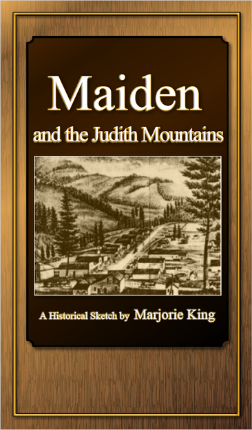
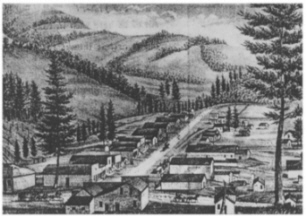
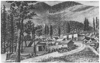
| Maiden dates from April 1881 when Snow and Kemper established a town site. They named the proposed town after the daughter of a friend, Mrs. James H. Conings, who they call the "Little Maiden". The town of Maiden was not platted and surveyed. Rather lots were delineated and claimed by the simple expedient of building fences around them. By 1882 the town boasted a number of log and lumber houses, eight saloons, two clothing stores, five general merchandise stores, a dry goods store, a butcher shop, a blacksmith, two barbers, a feed stable, a lawyer office, a doctor, a hotel and a restaurant. The attorney was S. C. Edgerton, the son of Montana's first territorial governor (Rocky Mountain Husbandman 1882; Wolle 1963). |

|
• Samples Grocery Store • Jail • Lime Rock Wilson Residence • Frenchmen Smelter • Saunders Livery Barn • Belanger Department Store • Bucket of Blood Saloon • Cole Blacksmith Shop • Culver Studio • Williams Drugstore • Maiden Hotel |
• Billy Jenkins Barbershop • Gies Saloon • Peterson Butcher Shop • Denny O'Brien Saloon • Beatty Dance Hall • Poland Hardware Store • Bullion Saloon • Bushnalt Store • Gies Meat Market and Bakery • Anderson Roller Skating Rink • Fat Jack Cabin and Law Office |

| ...to the pioneers, miners, woodsmen and merchants, this site is dedicated to your wisdom, strength and preserverence. |
| The Warm Spring District is located about 11 to 15 miles northeast of Lewistown near the headwaters of Warm Spring and Ford Creeks. The first gold strike occurred in the spring of 1880. By June additional discoveries were being worked on Maiden Creek, Alpine Creek, Warm Spring Creek and Ford Creek. |
| The Warm Spring District contains several small mining communities: Andersonville, Maiden, New Year and Gilt Edge were the most significant while Alpine and Rustle were of lesser stature. Andersonville was named after "Skookum" Joe Anderson, one of the area's original discoverers of gold in 1880. Anderson and David Jones were in the Black Hills in 1879 and from there wandered to the Yogo district and then to the Judith Mountains in the spring of 1880. In June they were joined by C. C. Snow and F. T. McPartlan. The first paying strike in the district occurred in Alpine Gulch on June 10, 1880. A few days later strikes were made on Warm Spring Gulch and then in Maiden Gulch. One prospector, J. R. Kemper, was said to have worked ground that paid $115 per sluice box (Wolle 1963; Foster 1990). |
| Located 1,500 feet from the Spotted Horse mine, the Maginnis group was composed of five patented claims including the Montana Lode, the Oro Cashe Lode, Oro Cashe Extension, Oro Cashe mill site and the Holter Placer. The mine was discovered just west of the divide between Warm Springs and Maiden Creeks in 1881
and worked until 1899. On the west side of the mine the town of Maiden developed. In 1884 the Maginnis Mining Company was incorporated by Messrs. Houser and Holter of Helena and capitalized to $500,000. The company purchased the Oro Cashe and the Montana Lodes and abandoned the small 2-stamp mill that previously worked the ores in favor of a Huntington mill. Concentrators, amalgamators and a 50 horsepower steam plant were also installed. The previous mill was said to have lost 60% of the ore values as it worked the soft lead carbonate ores of the mine (Hoyt 1915; Robertson 1950; Munson 1988) In 1887 the Maginnis Mining Company patented (MS#12134) the Oro Cashe lode and site properties and later the Montana lode.
They obtained the Spotted Horse mine in 1889. Production was expanded and reported to be profitable from 1886 to 1896. However, the mill apparently worked only intermittently and had a reputation for being closed. In 1889 twelve men were reportedly put to work repairing the mill and adding a cyanide circuit. The total production from this first period was estimated to be around $1,500,000 (Hoyt 1915; Robertson 1950; Munson 1988). In 1904 a lessee, G. M. Anderson, struck a rich deposit in a winze. Later that summer the mine was sold to the banking firm of Conrad-Stanford of Great Falls and Helena. The mine shipped its ore to the East Helena Smelter until the mill could once again be remodeled. A 60 horsepower gas hoist was in-
stalled on the shaft to facilitate the removal of ore (Munson 1988). The mine was reopened in 1909 and worked in a small way for threeor four years by the Gold Reef Leasing Mining Company. They added the use of a 10 stamp mill to the machinery lready at the mine's mill. Production from the second period was reported at only $328,000. Ores averaged $100 per ton, but one small body of ore netted $5000 per ton with select samples running $68,000 per ton. Ores above the adit levels were oxidized while those below contained some copper sulphides. Gold in the ore was free-milling or in tellurides associated with sulphides (Hoyt 1915; Robertson 1950; Munson 1988). The mine was worked from two adits, 300 and 1,450 feet long. A 225 foot winze was sunk in the lower adit at a point 800 feet from the portal. Several levels were driven from the winze. A south shaft was sunk on the Montana claim near the divide around 1897. It was reported that 1,500 tons of 60-ounce silver ore was shipped from this shaft to Wickes to be smelted. By 1910, 9,000 feet of underground had been developed. Heavy water flow in the lowest level prevented the extraction of some $16 gold ores. Numerous large cavities were encountered in the limestone; one of which was 150 feet deep (Robertson 1950). In 1915 the mine had again changed hands to the Dartmouth Land Company and its former owner Holter. The mine was reported to be employing underhand stoping methods and hoisting ore by hand windlass. The shaft had reached 426 feet when it encountered a diorite intrusion. No effort had been made up to that time to drift from the shaft. In 1916 the 10- stamp mill was overhauled and new equipment installed. The high grade ore
was run through the mill and concentrators while the low grade ore was worked by a cyanide plant. From 1904 to 1940 the mine reported 18,674 ounces of gold, 24,255 ounces of silver, and 21,807 pounds of lead were milled from 34,993 tons of ore (Hoyt 1915; Freeman 1916; Robertson 1950; Munson 1988). Reliable information located in 1980 indicates the total tonnage was nearer 14,993 as there appears to be an overage error in the recorded tonnages for the year 1912 when the small bonanza ore body was mined. Total gold production from the Maginnis is estimated to be 100,000 ounces recovered from approximately 35,000 tons of ore mined.George Wieglenda acquired the Maginnis property in 1932 and continued prospecting the accessible upper workings. Wieglenda died in 1957 and the property remains in his family to this day. In 1974 Viking Exploration Incorporated, operator of the Spotted Horse mine, leased the Maginnis but did little with it. Jerry Hanley, Wieglenda's grandson, leased the property in 1980 and continued exploring and trying to developing it. In 1986 Hanley subleased the mine to Chelsea Resources U. S.. Chelsea was also commencing operations at the Spotted Horse, Kentucky Favorite, and Cumberland mines. Under Hanley's direction a decline tunnel was driven from the Maginnis New Works area northwesterly towards the main works. Some ore was found at the New Works and the old workings were tapped. Chelsea failed on their entire Gold Hill project and later Blue Range Mining Company subleased the property. Blue Range was producing from two other mines in the district and milling at a centrally located mill located at nearby Heath, Montana. Again, under Hanley's direction the decline was driven to a point under the lowest level of the old workings. Access was gained to the old working from the decline and they were explored, mapped, and sampled. A shipment of high-grade ore was mined and shipped to the smelter at East Helena, Montana in 1991. An exploration drilling program was scheduled but Blue Range's entire Central Montana operations were shut down due to irresolvable problem at the Heath mill. Jerry Hanley continues exploring and pursuing the development of the Maginnis. |
| The Spotted Horse mine (24FR673) is located one mile east of Maiden on the west side of Maiden Canyon.The mine was discovered by Skookum Joe Anderson and David Jones in 1881. After extracting some high grade ore from the discovery shaft, Anderson sold the mine to Perry McAdow and B. Dexter. Although McAdow was confined to a wheelchair, his considerable mining knowledge allowed him to develop the property and by 1883 he was sole owner. Under combined management with his wife, a 10-stamp mill was moved from the Collar mine and erected on the Spotted Horse. Vanners were added to recover values from tellurides and sulphides. A rumored one million dollars of ore was reduced in this mill. Some of the telluride ore was so rich that it was taken out by a spoon and placed directly in small sacks. The mine was bonded to the Jay Gould Company in 1892, but they were not able to manage it properly and ended their effort deep in debt. The mine reverted to McAdow who then reportedly took out another million dollars ( Lincoln 1911; Lyden 1948; Wolle 1963; Munson 1988). In 1883 the mine was sold to the Maginnis Mining Company of Hauser and Holter. They spent $80,000 on a new 20-stamp mill and $20,000 on other mine improvements. The 2-compartment shaft sunk to 260 feet with three levels. The mine and mill employed 20 men and the mill was kept in constant operation. Despite these improvements, the mine could not pay its way (Munson 1988). By 1891, McAdow had repossessed the mine and was in the process of once again making it a fabulous producer. He radically expanded operations and soon had 200 men working around the clock and receiving a payroll of $23,000 per month. In 1893 a $100,000 gold brick from the Spotted Horse was proposed to head the Montana Exhibit at the World's Fair (Lincoln 1911; Lyden 1948; Wolle 1963; Munson 1988). In 1893 the mine finally left McAdow's hands and became the property of the Double Eagle Mining Company. In 1893 a body of rich free milling ore worth $30,000 was extracted from an open quarry. Free gold was observed in large masses imbedded in irregular shaped masses of fluorite. The ore was peculiar in that it did not contain lead. The Double Eagle Mining Company did well with the property, but a crooked manager skipped with the mill's profits. The property landed in the hand of its creditors, the Bank of Fergus County and the Power Mercantile Company of Lewistown. M. L. Poland then managed the mine until 1896 when it was sold to J. L. Bright of Columbus, Ohio. The property changed hands several more times until the St. Paul Montana Company acquired it as part of a larger deal with the Johanna Gold Mining Company. The St. Paul company was primarily interested in the Whiskey Gulch and New Year properties; the Spotted Horse was thrown in to complete the deal. As a result the mine languished. However, a 40 ton cyanide plant was erected to recover the lost values in the impounded mill tails. The process extracted 95% of the $12 gold per ton that remained in the tails (Lincoln 1911; Lyden 1948; Robertson 1950; Wolle 1963; Munson 1988). The Spotted Horse was closed in 1902 and remained idle for several years. In 1909 lessees shipped 23 tons of ore from the mine and in 1910 the mine was acquired by the Cumberland Gold Mining Co. In 1912 the mine reopened under lease to Coolidge, Bryant and associates. The mine worked four ore chimneys to a depth of 585 feet. The new company employed 15 men and in 20 months shipped $200,000 in ore and had, at the time of reporting, $145,000 was awaiting shipment. A new cyanide mill was built on the property in 1916. The new mill was rated at 100 tons but realistically could only work 75 tons per day. Prior to the construction of the mill only $20 or better ores could be shipped for treatment; the mill allowed $3 per ton ores to be worked. The operation reportedly was then able to produce $12,000 in gold per month. By 1916 the property had produced a total of $5,000,000 in ore; this accounts for over half of the district's total production (Hoyt 1915; Freeman 1916; Munson 1988). The mine was developed through a 2-compartment shaft that eventually reached 450 feet. A winze on the 450 foot level extended the mine down to 585 feet. In all, eight levels were developed. One ore shoot on the lowest level produced 850 tons of $22 ore (Robertson 1950). The mine continued to be worked intermittently until 1919. The increased war-time wages, the depletion of high-grade ores and the death of an active owner conspired to close the mine. Finally, a lessee working the mine quit hard rock to enter the oil business. The mill was dismantled around 1935 and all buildings and equipment removed from the property. George Wieglenda intermittently leased the property in the 1920's and early 1930's. Some ore mined by Wieglenda was treated at the Tail Holt mine. No production has been recorded since was recorded after 1936 and the workings were reported to be caved in 1948. In 1968 Larry Hoffman leased the property and began reopening and exploring the mine. In 1972 Viking Exploration Inc. acquired the property and continued reopening and exploration. Viking had the shaft reworked and the eight workings levels were active. In 1984 Minerals Inc. mined and shipped high-grade ore from the lower levels of the mine. Minerals Inc. also conducted a surface exploration program of drilling and soil sampling. In 1987 Chelsea Resources Inc., constructed a modern 50 ton per day vat leach cyanide plant and placed the property into production. The shaft was deepened to Level 8 and the winze sunk an additional 50 feet making the Spotted Horse the deepest mine in the district at approximately 700 feet. The adjoining Kentucky Favorite was worked in conjunction with the Spotted Horse. Due to inadequate funding and a lack of development work, Chelsea failed and the mine became the property of Fergus County. In the early 1990's it was sold at a sheriff's sale to the highest bidder, Blue Range Mining Company. Blue Range leased to a small venture that conducted a surface exploration drilling program on the Kentucky Favorite and then relinquished the property. Eventually Blue Range sold to individuals and the property ended up in the hands of non-mining people. Efforts are ongoing to reopen the mine. |
|
Collar The Collar mine is on the east side of Collar Gulch on Crystal Mountain, about two miles east of Maiden. It was the first mine to be developed in the Maiden area. The mine was discovered in August of 1880. The mine was developed by the Collar Mining and Improvement Company. A 350 foot adit was driven and a 190 foot shaft sunk to meet the adit. Drifts were driven on the 70 and 120 foot levels. The mill worked for only a short time. In 1881, part interest in the mine was sold to the Omaha Smelting Company for $30,000. In 1882, the district's first mill, a 20-stamp mill, was erected; the mill featured 850 pound stamps, 12 pans and 6 settlers.Improvements were made in the mill. Beginning in 1884, the mine was sold to St. Paul interests, but the mine was quickly attached and then sold at sheriff's sale. The mill equipment was bought by P. W. McAdow and moved to the Spotted Horse. The mine was later developed in 1906 by the Bellis Brothers who drifted 600 feet into the mountain. The mine shipped cyanide ores with traces of tellurides. The first contact with this ore was 40 feet thick. By 1906 the mine was reported to have shipped a total of $125,000 in ore (Anon 1906; Robertson 1950; Munson 1987). Cumberland
The Cumberland mine (24FR675) is in the Gilt Edge sub-district half a mile northeast of the district's leading producer, the
Spotted Horse. The mine is composed of the Cumberland, Cumberland No. 2, Buffalo, North Pole, and North Kentucky claims. The mine was located in the 1880s but was not developed until 1904 when it was leased and bonded by Oscar Stephens and Peter Rosse. They mined and shipped only high grade ore from a 183 foot shaft with three levels. One raise begun 50 feet below the surface showed good ore values to grassroots. The partnership expended $7,000 on mine development and redeemed the bond in May. In 1906 the shaft was sunk to the 250 foot level. An adit 1,000 feet long was later driven to connect with the bottom of the shaft. A winze, 30 feet from the portal, was sunk in ore to a cross cut. The sudden death of Oscar Stephens closed the mine in 1907. The next year the mine was sold to Theodore L. Lammers & Co. who formed
the Cumberland Mining Co. A 150 ton cyanide plant was installed in 1910 to work the low grade ores; the mill featured a crusher, rolls and Wilfley tables worked in conjunction with a 100 ton cyanide circuit. From 1910 to 1915 the mine was owned and operated by James Breen who employed 60 to 75 men. The mine was closed in 1912 and reopened in 1916 by lessees. All of the ores above adit level had been removed by 1916. A 40 foot winze led to a discovery of further ores below the adit level. By 1916, the mine had produced $270,000 in ore (Wolle 1963; Munson 1988).
From 1916 to 1918 the mine was leased to Coolidge, Bryant, Wieglenda and associates. They reduced the ore in the nearby Spotted Horse mill. Some cleaning up was done around the Cumberland mill in 1923, but the mill remained inactive until it was destroyed by fire in 1948. When visited in 1988, a large glory hole, collapsed portal, several prospect pits and adits were recorded in addition to the remains of the mill (Anon 1906; Freeman 1916; WPA 1941; Robertson 1950; Munson 1988). Gilt Edge
The Gilt Edge (24FR638) mine is on the east side of the mountains south of Maiden. The lode deposits were located in 1884 by Wilson, Anderson and Munson; the principal claim being the Gold Reef. Soon thereafter the mine was sold to Butts, Collins and Armington. These men erected a crude cyanide mill at the base of the mountains to work the ore and operated the mine for a short time. But the ores were difficult to reduce and so little further development occurred. In 1893 the Ammon-Stivers Mining Co. (a group of Great Falls men lead by Robert A. Ammon) bought the Gilt Edge mines and rebuilt the cyanide mill. It was the first cyanide plant of its kind in the United States. The $35,000 improvements allowed 100 tons of $20 ore to be worked per day. Fifty workers and their families established a small mining camp at the mill. By the end of 1893 the mill had produced $60,000 in bullion and the town had grown to include numerous businesses and supported five saloons. Despite this apparent boom, the mill was still inefficient and so the company could not meet payroll. Some miners continued
to work with hopes of future payment. When the company began to write worthless checks, a sheriff was dispatched to shut down the mill. Two employees who were tipped off about the sheriff by creditor Frank Moshner took all the bullion in the mill and managed to get it to Great Falls. Although the sheriff followed in hot pursuit, the bullion was sold and the money given to Ammon. An unusually severe winter followed and the miners and their families were reduced to starvation. When their plight became known, food and other aid were sent from the valley and company warehouses were opened. Ammon eventually ended up in Sing Sing Prison for activities in the east (Robertson 1950; Wolle 1963; Foster 1990).
The camp was nearly deserted in the mid-1890s while the mine and mill were operated by leinholders. In 1897 the property was purchased by the Great Northern Mining & Development Co. By 1898 the mines were again in full production and in 1899 a new 150 ton mill was erected closer to the mine. Later, this mill was expanded to 350 tons and had six leaching tanks each with a capacity of 175 tons; these were used in conjunction with a Brown straight line furnace. A new haulage adit was driven from the mill to connect via raises to the mine (Robertson 1950).
In 1902 the mine was sold to the Gold Reef Mining Co. who operated the mine and mill until 1909. In 1902 the main adit was 5,000 feet long with 2,000 feet in ore bodies. In 1904 the mine and mill were shipping $30,000 to $35,000 in gold bullion each month. Ultimately, the mine also included a 300 foot incline shaft and a 200 foot winze sunk on the haulage adit. An incline shaft begun in 1904 and sunk to 100 feet was ultimately extended to 300 feet and a 200 foot winze sunk on the haulage adit. John A. Drake became the owner of the mine in 1909 and leased it out to the Gilt Edge Lease Mining Co. until 1912. At the time of the sale the mine was said to contain 2.5 miles of underground workings. The mill was dismantled sometime before 1916. A cyanide plant was erected at the first mill site in 1918 to rework 8,200 tons of tailing. Some testing was done on the site in 1940 and 1941 by the Newmont Mining Company. The mine is credited with $1,250,000 in gold. Most of the gold worked in the mill came from the Gold Reef and Great Northern properties (Anon 1904; Freeman 1916; Robertson 1950). Mammoth The Mammoth mine is located on the southeast side of Pekay Peak about 2 miles north of Gilt Edge. The mine was located in the 1880s, but little work was done until after the turn of the century. A 60 ton cyanide mill was constructed on the property in 1904 to run $6.00 per ton gold ore. However, the mine and mill were closed by problems with the poor returns and with stockholders after only a short time of production. In 1919 the property was operated by the Judith Mountain Mining Co. and 250 feet of development was done. The mine was worked out of adits, open cuts and shallow shafts. The mill burned down in 1922 (Freeman 1916; Robertson1950). New Year The New Year property was located in the NE of section 16, T16N, R19E and was situated west of Maiden on the north side of the range near the top of the ridge at the headwaters of New Year Creek. The property, consisting of 18.5 claims, was discovered in 1880. In 1897 the New Year and Old Bach were owned by Harmon
and Norman. In 1898 a small mill and cyanide plant were built in the bottom of the gulch two miles downhill from the mine. However, the cyanide process was not successful owing to too coarse of material being introduced to the cyanide.
In 1902 the mill was enlarged and the mine workings extended by a 500 foot adit. Off the main shaft of the mine a crystal cave was encountered; the chamber measured 300 feet by 100 feet. Although extensively developed, the mine reported little production. While the milling problems appeared to be solved, the operation was forced to close by litigation.
The mill was reopened at 150-ton capacity in 1911 when the Rheingold Mining Co. obtained the property. In 1912 the old mill was torn down and a 300 ton mill with cyanide plant erected. An undated publication from this period stated that an aerial tram was to be built at a cost of $15,000. Other in-place improvements included a 1.25 mile ditch built for $2,000 and a 10 -drill compressor. Fifty men were employed in the mine and mill. The plant was powered by coal from an adjacent coal mine also owned by the company. From 1911 to 1912, 10,000 tons of ore were sent through the mill, but only 206 ounces of gold and 11 ounces of silver were recovered. For obvious reasons, the mine was shut down and its equipment was sold (Robertson 1950).
In 1915 the adjacent Gold Acres mine was opened with an 800 foot adit with drifts and raises. Ore valued at $4 per ton from this mine was then treated in the New Year mill (Freeman 1916; Wolle 1963). Tail Holt The Tail Holt mine is located in NE section 30 T17N, R20 E on the northeast side of Big Grassy Peak, about three miles northeast of Maiden. The mine was discovered in 1911, worked for six months and then abandoned. In 1927 the mine was actively developed by Coolidge, Bryant, Wieglenda and others. In its first year only one carload of ore was shipped. The next three years the mine was developed with several hundred feet of drifts and crosscuts. A mill and cyanide plant were erected on the mine to work the ore. From 1927 to 1934 when the operation was closed, the mine was credited with 1,166 ounces of gold and 647 ounces of silver from 2,961 tons of ore. The mine continued to be developed and mined through the 1930s (Corry 1933; Robertson 1950). War Eagle The War Eagle mine was situated in NW section 7 T16N, R20E near the Cumberland, one mile south of Maiden on a ridge extending northwest from Pekay Peak. The claim was the first lode mine in the district when it was staked by David Jones and Joe Anderson in 1880. The mine attracted attention to the lode mining possibilities
of the district when ore samples ran 80 ounces of silver and some gold per ton. In 1885 the mine was owned by Jones, Anderson, McAdow and Dexter. In 1905 it was owned and operated by Burr and Stuart; later it would be owned by Burr alone. By 1910 the mine was shipping primarily zinc ore with some gold, silver and lead values. From 1910 to 1913 the mine produced 4 ounces of gold, 510 ounces of silver, 2,348 pounds of copper, 74,464 pounds of lead and 159,295 pounds of zinc from a mere 340 tons of ore. The mine was idle after 1913 (Robertson 1950).
The mine was worked through three adits and an incline shaft sunk on a chimney of ore at the limestone-porphyry contact. The upper adit connected to the shaft at 80 feet. Some oxidized ore was hauled to the Spotted Horse mill and some lead ore treated at a small lead smelter in Maiden. After 1911, the ore was shipped to the Ozark Mining and Refining Co. in Kansas (Robertson1950). Whiskey Gulch The Whiskey Gulch claims are on the south side of a ridge south of Whiskey Gulch about two miles south of Gilt Edge. The claims were located around 1884 or 1885. The property was first active at the turn of the century. Ore was sent down a short tramway to a small mill in Whiskey Gulch. In 1899, a 100-ton cyanide mill was built by the Central Montana Mines Co. By 1904 the mine was owned and operated by the Chicago Montana Mining Co. and worked in conjunction with the Big Six mines. The mill was expanded to 220 tons and worked ore from both the Whiskey
Gulch and Big Six. When last worked the property was in the hands of the Cave Gulch Mining Co. Although earlier figures are not available, the mine reported $165,000 production from 1903 to 1904 while working $5.50 per ton gold ore. Problems with the stockholders idled the mine prior to 1916 (Anon. 1904; Freeman 1916; Robertson 1950).
Other important mines in the district which were discussed by Weed and Pirsson (1898) and Robertson (1950) were the Tail Holt, Silver Bullion (Peter Rosso's mine), Black Bull (or Globe), Allen Silver, Florence (or Get Even), Pilgrim, Black Hawk, Justice,
Matthews and Last Chance No. 2, Great Falls and Judith Mining Co., Western Mines Corp, Bolivia, Northern Pacific, Last Chance, Old Nelson, Clara May and Ella, Depression, Boulder, Black Diamond, Hardscrabble, Wacasek, She, Peerless, McEvany (or Big Six), Iron Chancellor, White Elephant, Goodwin, Ruby Gulch and Bay Horse. BIBLIOGRAPHY
Abandoned Mine Reclamation Bureau (AMRB)
Blixt, John E.
Byrne, John and Frank Hunter
1901 Twelfth Annual Report of the Inspector of Mines of the
State of Montana. Independent Publishing Company, Helena.
Byrne, John and John J. Barry
Calderhead, J. H.
Calderhead, J. H. and O. M. Holmes
Corry, Andrew
Courtis, William Monroe
Deal, Babbie and Loretta McDonald, editors
DeKalb, H. L.
Ferguson, Henry Gardiner and L. P. Benedict
Forrest, Richard A.
Foster, John R.
Freeman, Henry C.
Freeman, Otis W.
Freeman, Otis W.
1917 "Mineral Prospects in Fergus County", Engineering
and Mining Journal, Vol. 103, pp. 660-662.
1919 "Geography and Geology of Fergus Co., Montana",
Fergus Co. High School, Bull. 2, Lewistown.
GCM Services
Hall, J. H. and M. L. Rickman
Heritage Research Center
Hogan, Joseph and Jacob Oliver
1892 Fourth Annual Report of Inspector of Mines, for the fiscal
year 1892, Printers & Binders, Helena.
Hoyt, B. F.
1915 "Gold Hill Section of Maiden District, Montana",
Mining and Engineering World, Vol. 42, No. 4, pp. 171-172.
Kemp, James Furman
Lingren, Waldemar
Lingren, Waldemar
Lyden, Charles J.
Miller, Don C.
Mineral Argus
Munson, Gene
GCM Services, Butte.
Penkake, Judith
Robertson, Almon F.
Rocky Mountain Husbandman
Sahinen, Uuno M.
Shoemaker, C. S.
Swallow, G. C. and J. B. Trevarthen
Swallow, G. C., J. B. Trevarthen and Jacob Oliver
Weed, Walter Harvey and Pirsson, Louis V.
Weed, Walter Harvey
1907 Copper Mines of the World, New York.
Western History Research (WHR)
Wolle, Muriel Sibell
Work Projects Administration (WPA) Mineral Resources Survey
1941 Montana Mine Index, An Alphabetical Index Arranged
by Counties, Districts and Mines of Information on Montana
Mines from 1867-1940. Montana School of Mines, Butte.
Anonymous
1906 "The Maiden District, Montana", Mining
World, Vol. 24, No. 21, p. 636.
1910 "Judith Basin, Montana", Mining and Scientific
Press, Vol. 101, No. 13, pp. 398-400.
1976 "Fergus County Argus, 1901 Edition Reprinted by the
Lewistown News-Argus
Courtesy MT Dept of Environmental Quality
Updated Edits provided by Jerry D. Hanley |
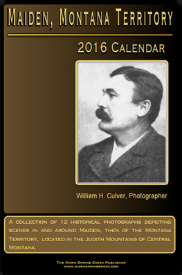
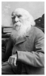
| 2016 William H. Culver Calendar |
| Maiden, M.T. Photographer |